
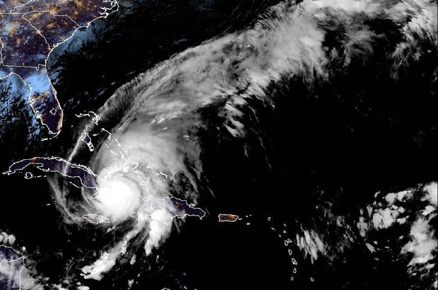
Hurricane Melissa was hitting eastern Cuba hard on Wednesday after slamming Jamaica as a Category 5 storm. Melissa was one of the strongest hurricanes ever recorded in the Atlantic basin when it reached Jamaica Tuesday afternoon.
The Miami-based National Hurricane Center said Melissa “is expected to remain a powerful hurricane when it moves across the Bahamas later today and passes near Bermuda on Thursday night.”
Melissa, the 13th named storm of the Atlantic season, isn’t expected to have major impacts on the mainland United States.
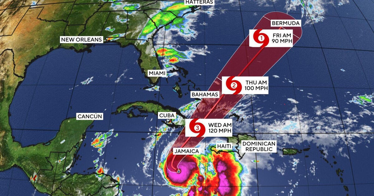
Melissa’s forecast and path
“On the forecast track,” the Miami-based National Hurricane Center said, “the core of Melissa is expected to cross eastern Cuba this morning, move across the southeastern or central Bahamas later today, and pass near or to the west of Bermuda late Thursday and Thursday night.”
The storm made landfall along Jamaica’s southwestern coast at around 1 p.m. EDT on Tuesday, packing maximum sustained winds of 185 mph, the hurricane center said. Hurricanes reach Category 5 — the top of the Saffir-Simpson Hurricane Wind Scale — when their winds hit 157 mph.
Melissa was still “an extremely dangerous” major hurricane when it got to southeastern Cuba.
At 5 a.m. EDT, the NHC said Melissa’s core was some 60 miles west of Guantanamo and about 230 miles south of the central Bahamas. Its maximum sustained winds were 115 mph, meaning it remained a Category 3.
Melissa was moving northeast at 12 mph.
Hurricane-force winds extended out up to 30 miles from Melissa’s center and tropical-storm-force winds extended out up to 185
miles.
Peak storm surge accompanied by destructive waves is forecast to reach 8 to 12 feet in Cuba, 5 to 8 feet in the southeastern Bahamas and 2 to 4 feet in normally dry ground of the Turks and Caicos Islands, the center said.
The storm’s extremely slow pace as it hit Jamaica raised its potential destructive force.
The strongest previous hurricane to pound Jamaica was Gilbert in 1988, which killed 45 people and caused more than $700 million in damage.
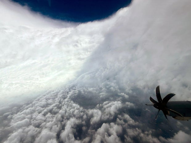
The crew of a U.S. Air Force 403rd Wing “Hurricane Hunters” flight ran into severe turbulence as it approached Melissa’s eyewall on Monday and had to return to their base in Florida, but they did capture stunning images of the center of the storm. Another flight on Tuesday to gather data on the hurricane also had to turn back after hitting strong turbulence.
Hurricane advisories
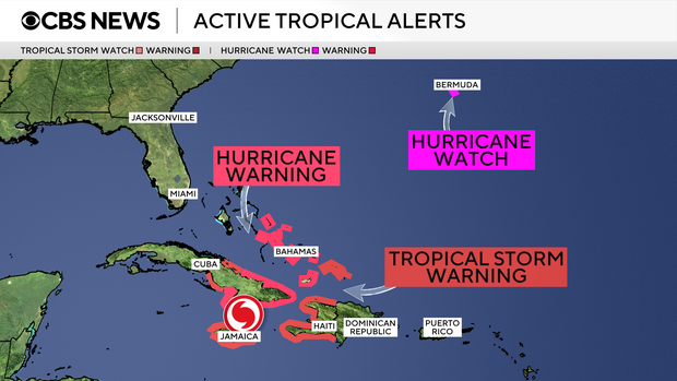
A hurricane warning was in effect early Wednesday for the Cuban provinces of Granma, Santiago de Cuba, Guantanamo, Holguin and Las Tunas and for the southeastern and central Bahamas. A hurricane watch was up for Bermuda.
And a tropical storm warning is posted for Jamaica, Haiti, the Cuban province of Camaguey and for the Turks and Caicos Islands.
In Cuba, a hurricane warning was in effect for Granma, Santiago de Cuba, Guantánamo, Holguin and Las Tunas provinces, while a tropical storm warning was in effect for Camaguey province.
Cuban President Miguel Díaz-Canel Bermúdez said Tuesday night on social media that authorities had evacuated 735,000 people.
The U.S. Naval Station Guantanamo Bay said it was moving “non-mission-essential” U.S. citizens off the island in groups ahead of severe weather from Melissa. About 1,000 U.S. military personnel have been evacuated.
Rainfall forecasts
Melissa is expected to bring 3 to 6 inches more to Jamaica, where the storm’s total rainfall will be between one and two feet, the NHC said, adding that “isolated areas near 30 inches will be possible over mountainous terrain. Ongoing catastrophic flash flooding and numerous landslides will continue today and into tonight.”
For eastern Cuba, the center said 10 to 20 inches of rain can be expected through today with local amounts of as much as 25 inches possible over mountainous terrain. “This will cause life-threatening and potentially catastrophic flash flooding with numerous landslides,” the center warned.
As for the southeastern Bahamas, “Storm total rainfall of 5 to 10 inches are expected today, which will result in areas of flash
flooding,” the NHC said. “For the Turks and Caicos, rainfall totals of 1 to 3 inches are expected.”
Climate change fueling the storm
Above-average Atlantic Ocean temperatures, made worse by climate change, helped Melissa rapidly intensify into a major hurricane, according to climate scientists.
“That part of the Atlantic is extremely warm right now — around 30 degrees Celsius (86 degrees Fahrenheit), which is 2 to 3 degrees Celsius above normal,” Akshay Deoras, a meteorologist at the University of Reading in the U.K., told The Associated Press. “And it’s not just the surface. The deeper layers of the ocean are also unusually warm, providing a vast reservoir of energy for the storm.”
Stronger winds, heavier rainfall and higher sea level rise will make storm surge more intense.
Preliminary data from Climate Central, a nonprofit group of scientists monitoring the effects of climate change, suggests that climate change has increased Melissa’s wind speed by 10 mph.
“Climate change is fundamentally changing our weather. It does not mean that every single tropical cyclone is going to go through rapid or super-rapid intensification. However, in our warmer world, it will continue to increase the likelihood of storms going through rapid and super-rapid intensification,” Bernadette Woods Placky, chief meteorologist at Climate Central, told The AP.


